24.A Northward along NZ Route 3 South of Hamilton under a Brooding Sky, 19 May 2013
Winter is
triply here in Te Awamutu. Firstly, meteorological winter began on 1 June,
albeit nearby Mt Pirongia received its first snow flurries in late
May. Usually the first snows don’t appear there until July, or so I'm told. Secondly, the winter
solstice occurred on 21 June, so at least the days are getting longer, as they must in winter, although only by seconds now. Thirdly, we had our first real frost of the
season under the full moon of 23/24 June. Winter is here.
Yet
winter on the North Island is a gentle affair compared to winter in the
Northern Hemisphere. After all, 81 percent of the Southern Hemisphere is covered by
water, while 61 percent of the Northern Hemisphere is waterlogged. Seasonal weather swings are
bound to be less severe south of the Equator, at least beyond the ice-olated
Antarctic. Sure, they've had snow at lower elevations in the South Island. But that's customary. Only the likes of Tongariro and their surrounding territory have gotten good snow dustings here on the North Island.
While
flowers continue to blossom in Te Awamutu, we can’t help but take note of the
various calendars that at least notionally act as time-marks between one season
and the next. Jean’s locum tenens service comes to an end on 5 July and shortly
thereafter we’ll be leaving New Zealand for our home in the States,
stopping along the way in Fiji and Arizona. We’re beginning to cast off, give away, trim down, set aside, save, and then
pack up—test wise—so that our luggage comes within the weight limits set by Air New Zealand.
In the spirit of casting off, I’ve
decided to devote this blogpost to gleaning photos that would otherwise be left
behind—at least figuratively—in New Zealand. You'll find below a scattershot
collection of New Zealand sights, in some cases landmarks, that I’d like to
share. We’ll go from south to north across New Zealand. The first set of shots (24.B thru G) were taken in Dunedin, which Jean and I visited in early April. In the 19th Century Dunedin was New Zealand's most populous city, first settled by immigrants from Scotland. It is home to the University of Otago, the country's oldest university. The campus is largely but not entirely bereft of buildings of note. The city, on the other hand, is well endowed with humane architecture endowed from its golden past. Foremost among these is the building that serves as the visual signature of the city, the Dunedin Railway Station. Dunedin is a hilly city nestled against the sea. The boundaries of the city are well-defined, which (among other things) means sheep may safely graze next to homes on the fringe of town (Photo 24.D). There are a number of prominent churches about town. Two that we saw inside and out are St Paul's Anglican Cathedral and the city's premier Presbyterian church, First Church of Otago.
24.B Dunedin Railway Station Clock Tower
24.C Vista of Dunedin
24.D By the Pacific at Dunedin
24.E St Paul's Anglican Cathedral, Dunedin
24.F First Church of Otago, Dunedin
24.G Dunedin Railway Station Facade
Jean and I have spent a good deal of time touring New Zealand by car, bus, and train. Photos of the Northern Explorer appeared in the preceding blogpost. Below you'll see a photo (24.H) of the Jucy Cruize bus that we rode on a one-day round-trip (or return) journey between Queenstown and Milford Sound, described in an earlier post. Kiwi bus drivers face considerable challenges, not least that within the national highway system (signified as 'State Routes'), only about 2% of the roads are divided, grade-separated expressways (or motorways). Kiwi bus drivers and long-distance truck drivers are courteous and competent (so far as I've experienced). The Queenstown/Milford Sound one-day roundtrip must be one of the most challenging driving tasks in all New Zealand. That's why I have to post the picture of the bus. I didn't ask the driver, Oz, for permission to publish his photo. I'm happy to publish a portrait of the kind of machine that enables tourists to get to Milford Sound and back in one day, thanks to professional, dedicated drivers.
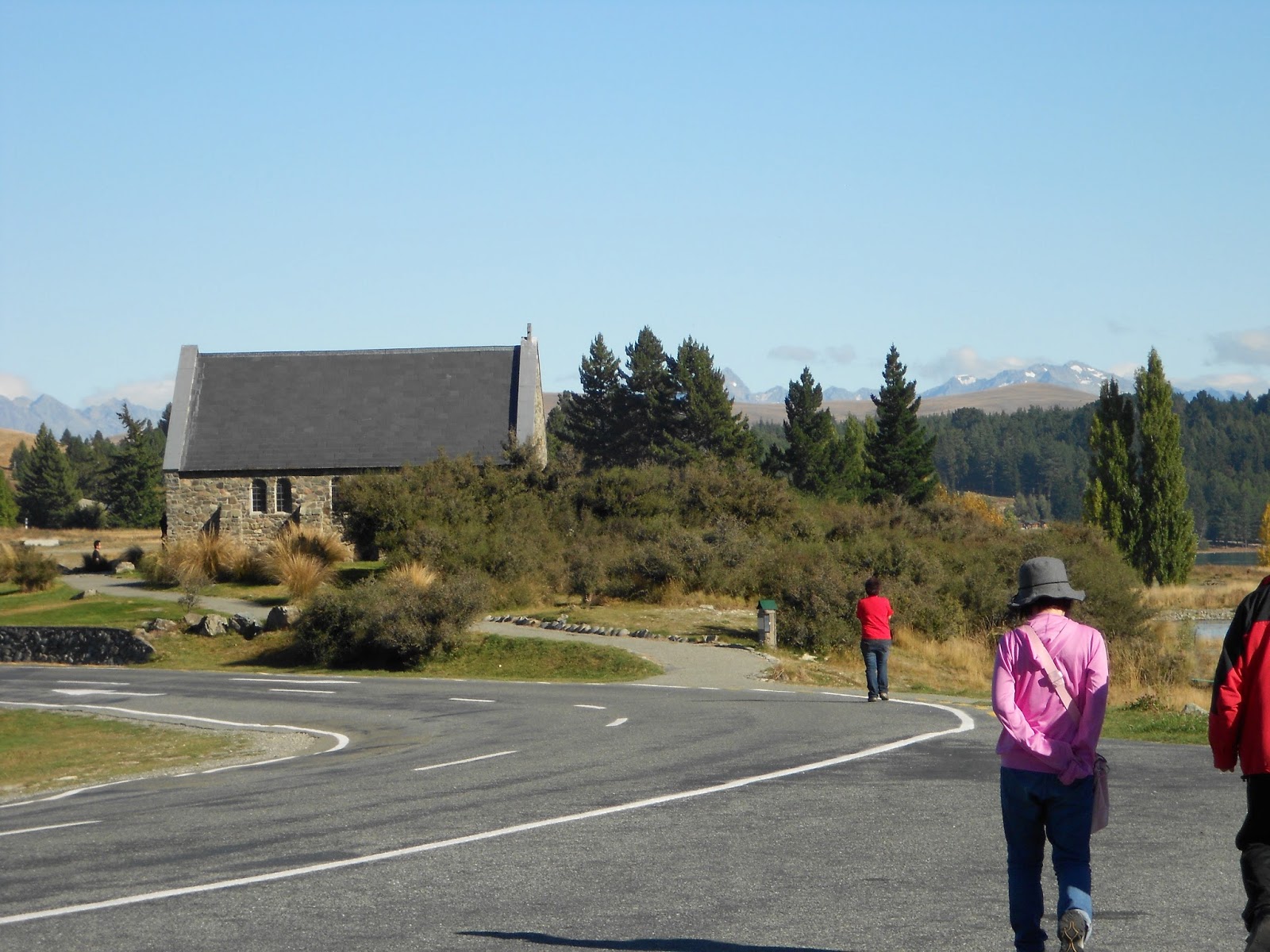
The photos from Lake Tekapo were taken on our bus journey from Christchurch to Mt Cook Village in early May. The Church of the Good Shepherd, on the south shore of the lake, was built in 1935 largely thru the donation of one lady (so we were told). It was the first church in New Zealand's arid grassland known as the 'Mackenzie Country' or 'Mackenzie Basin'. Sheepdogs are recognized as indispensable to the sheep ranching that characterizes the Mackenzie. Appropriately, a statue to these dogs has been raised near the Church of the Good Shepherd.
24.H Jucy Cruize Bus (aside Route 94, the Milford Road)
24.I Waiting at the East Portal of the Homer Tunnel, Route 94
24.L Bronze Statue of Collie Sheep Dog, Lake Tekapo
There's more to Christchurch than ruin left by earthquakes. The International Antarctic Centre, within walking distance of the city's airport, is worth a visit. And perhaps some day the city's renewed theatres will also again draw visitors. While much of the central city's high-rise buildings were devastated, one of the city's municipal office buildings survived intact, and therefore (I think) can serve as a memento of Christchurch's hope... along with the numerous, inventive container structures highlighted in a previous blogpost.
24.M International Antarctic Centre, Christchurch
24.N In a Simulation Chamber at the International Antarctic Centre
24.P Municipal Office Building, a Christchurch Survivor
Wellington's Cable Car Museum rates a shot below. And Wellington's Old St Paul's, I thought, deserved more than the one interior shot I had previously shared.
24.Q Antique Cable Car, Wellington
24.R Interior, Old St Paul's, Wellington
During her locum tenens, Jean has served in three towns, two of which I've written about in posts: Te Awamutu (Blogpost 13.05) and Taumarunui (Blogpost 13.09). The third town, Te Kuiti, won't be featured in a blogpost, except for the photo below, showing part of the skatepark built in a corner of the town's former railway yard.
24.S Te Kuiti Skatepark
We made a brief foray to the Taranaki Peninsula (on the North Island's Tasman Coast) in late April. We stayed in the city of New Plymouth. Mount Taranaki (also once known as Mount Egmont) and New Plymouth never became the topic of a blogpost. I thought I should at least include a few photos from that foray among the scattershot of this post.
24.T Port Taranaki, New Plymouth
24.U Coastal Walkway in New Plymouth
24.V Mount Taranaki / Mount Egmont
This past Saturday, Jean and I paid our third visit to the Maungatautari Ecological Island Trustpark. Herewith below are three photos, including a shot (the last) taken towards the Waikato River from a flank of Mount Maungatautari. It was a beautiful day.
24.W Canopy Trees Seen from Observation Platform at Maungatautari Ecological Island
24.X Fern Tree under the Canopy at Maungatautari Ecological Island
23.A On the Northern Explorer Descending from the Central Plateau with the Doubling BackRailway Route Visible Below, 1 June 2013
'When in Rome do as the Romans do,' so said St Ambrose to St Augustine, or so we're told. But sometimes in traveling there are dividends to be found in not doing as the Romans do. And so, going against the advise of Ambrose, Jean and I traveled by rail recently in our trek south to Wellington (more on Wellington in Blogpost 13.21). Rail travel is passé among Kiwis, but not rail transport. By that I mean cross-country rail travel has almost completely disappeared but not railway usage. Three cross-country services still exist, which are directed at travelers or tourists. Two are on the South Island—the Coastal Pacific and the TranzAlpine—and one on the North—theNorthern Explorer. The five-days-a-week Capital ConnectionTranz Metro service between Palmerston North and Wellington and the six-days-a-week Tranz MetroWairarapa Connectionbetween Masterton and Wellington, unlike the aforementioned three, are really longer-distance commuter services.
Metropolitan rail services in Auckland and Wellington are where the passenger service miles are generated in New Zealand. Auckland, with a relocated main city station, has seen its commuter rail annual ridership grow from two million in 2005 to about ten million in 2010. The on-going electrification (25 kV AC) of Auckland's commuter rail lines will permit speedier service, which with other factors will drive ridership even higher. Wellington's metro rail service (Tranz Metro) carries about eleven million passengers annually.
If metro rail service has become the heart of New Zealand's rail passenger service, the romance continues to reside out on the lines, where the great scenery of the country is on offer. We decided to travel south from Hamilton to Wellington via rail, returning via Air New Zealand, over the Queen's Birthday holiday weekend (1 thru 3 June 2013). The Northern Explorer currently runs southbound on Mondays, Thursdays, and Saturdays and northbound on Sundays, Tuesdays, and Fridays. Despite the somewhat surprising fact that the North Island Main Trunk Railway ('NIMT') is electrified between Hamilton and Palmerston North, the Northern Explorer was hauled by a diesel locomotive throughout the trip. The trailing consist was as follows: an open-air observation car or 'van' (in Kiwiese), a 63-seat coach, a café car (equipped to serve wheelchair-bound passengers), another 63-seat coach, and a luggage van. Reportedly this equipment was put in service on the North Island in early 2012. The café car and coaches are equipped with panoramic windows and clerestory windows above the panoramic windows, thereby affording rather unobstructed views.
We left Hamilton on 1 June a few minutes late, but soon made up the time. Heading south from Hamilton to Te Awamutu (TA) we were rolling through the lush, hedgerow-loving Waikato country, famous for its dairy production. South of TA the train enters New Zealand's so-called 'King Country', the land where the Māori Kingitanga Movement spurred the creation of a Māori monarchy. The first king was in fact born in Te Awamutu. But the heart of the King Country lies to the south (The succession of a Māori king or queen extends to this very day, albeit without legal authority within New Zealand's polity). The King Country served as a redoubt for the Māori in no small part because of its contorted topography, a topography that made military penetration and railway-building difficult. Our first stop beyond Hamilton and in the King Country was at Otorohanga, a small, charming town that serves as the gateway to the Waitomo Caves. Just a few passengers boarded here. After leaving Otorohanga we passed through Te Kuiti and Taumarunui, both once important railway towns, whose status has been lost with the railway's electrification (25 kV AC) since 1988. Just north of Taumarunui we passed thru the junction at Okahukura, where the line to Stratford (and thence to New Plymouth) joins the NIMT. New Plymouth is the most important city in New Zealand's Taranaki Region (on the North Island's west coast). The Stratford/Okahukura Line ('SOL') is no longer in service for conventional railway purposes. New Plymouth is served by an alternate railway line. But the SOL now sustains a tourist-oriented operation (Forgotten World Adventures), where riders operate golf carts over the rails through what is also called the 'Lost World'. The line has twenty-four tunnels in 144 km (89 miles), just further evidence of the contorted topography of the King Country.
South of Taumarunui the ascent to the Central Plateau dominates the lay of the railway. Doubling-back arrangements and even a complete loop, the Raurimu Spiral, are required to make railway ascent or descent practicable. Once on the plateau the Northern Explorer soon arrives at National Park, the name eventually affixed to this station (1926), although not when the line was opened in 1908. In 1908 Tongariro National Park, served by the station, was New Zealand's only national park other than Mt Egmont National Park (established in 1900 in the Taranaki Region). A number of passengers disembarked at National Park, no doubt to visit Tongariro (See post 13.20). The nearby mountain peaks happen to be invisible, enshrouded in clouds, this June 1. Splots of snow lie here and there about town. Larger fields of snow are visible on the flanks of one of the mountains. And at the station café a fire is going to keep the customers warm.
At one time I had wondered whether the Northern Explorer allowed passengers sufficient time at the National Park station to eat lunch there. I knew the station had a café, which has a good reputation. Both the northbound and southbound Northern Explorers are scheduled to leave National Park at 1:15 PM. But, of course, with the café car in the train's consist, there was no need to gulp food at some wayside station. On board there were hot and cold beverages, both soft and hard. And there were numerous offerings of what Kiwis call 'cabinet food'—salads, lasagna, quiche, Kiwi pies, and the like, which could be readily heated in the microwave if required. The train manager and his assistant (the entirety of the train crew, not counting the engine driver as in the 'train crew') worked the café car (among other duties). They offered to deliver food and beverage orders to passengers in the coaches. For lunch I happened to have a Moroccan salad with a roll and Jean a tossed green salad laden with squash chunks. The Moroccan salad was good, the squash salad excellent. Indeed, Jean decided to re-create that latter salad after we returned to TA, where we dubbed it the 'Explorer Salad'. The food and beverage prices aboard the train were no more than what you'd pay in a typical Kiwi café.
We chose to have our lunch after leaving National Park, which we left as soon as the departing passengers had retrieved their luggage from the luggage van. Soon, to use railway lingo, we were 'running hot', meaning we were running ahead of schedule. At one point on the journey the train would be running as much as eleven minutes hot, a circumstance made possible by at least two facts: (1) that seating is by reservation only and (2) that, if all reserved passengers are aboard, the Northern Explorer will leave early (all other things being equal). One of the nice features of the Northern Explorer is that thru headsets at each seat one can listen to occasional, GPS-activated narratives about passing locales and sights and about the railway line itself, especially its history. The train passes over a number of substantial bridges, but (alas) none are portrayed in the photos below.
Beyond National Park our next stop was Ohakune, a gateway to the Turoa Skifield (at the southern end of Tongariro National Park). A northbound freight or goods train (loaded per usual with single-stacked containers*) was waiting at Ohakune for our train's arrival before resuming its journey north.
The following stop was about two and a half hours beyond Ohakune, at Palmerston North, which is about 140 km (87 miles) north of Wellington. We traveled through more of the Central Plateau and then descended into highly varied countryside. At Palmerston North we lingered for perhaps five minutes as the train crew retrieved luggage from the luggage van. A good number of passengers disembarked here. I wouldn't call Palmerston North a tourist destination, so apparently these disembarking passengers could be labeled as 'Kiwi travelers' and not (like ourselves) mere 'tourists'. In New Zealand's summer the entire Northern Explorer journey would be in daylight. But given our season of travel the daylight came to an end somewhere between Palmerston North and our next stop at Paraparaumu, whose station is in the electrified zone (1.5 kV DC) served by Wellington's Tranz Metro trains.
We were considerably delayed in attaining the train's final stop, Wellington Railway Station, because of engineering works being done on an extended, holiday weekend. The work was part of a project to increase capacity on the lines leading into the station. No matter. Right across the platform where we disembarked were shuttle vans waiting to take passengers to hotels or motels and to the ferry docks (for boats to the South Island, among other places).
The Northern Explorer enables anyone to traverse the length of much of the North Island (between Auckland and Wellington) in one day in a commodious fashion without all the hassles of driving or the constrained conditions of a bus. We enjoyed our day on the train and would recommend it.
Warm regards,
Tim (& Jean) *P.S. Railway lines in the KiwiRail system are built to so-called 'Cape gauge' (3ft 6 in), not 'Standard gauge' (4ft 8.5 in). Cape gauge is cheaper to build than Standard gauge, allowing as it does for more severe curvature--a key consideration in New Zealand. But Cape gauge leads to less capacious loadings than Standard gauge, so (for example) Kiwi container freight trains are single-stacked, rather than double-stacked, as has become customary in North America. P.P.S. (Posted 11 November 2014 @ Napier, New Zealand) Immediately below is a link to the long version of a KiwiRail advertisement that I saw on television last evening. Most of the advertisement (shown immediately below) devotes footage to the TranzAlpine negotiating the parched rain-shadowlands east of the Southern Alps. A subsequent, variant ad (also shown below) gave more footage to the Northern Explorer and the Coastal Pacific negotiating their routes.
P.P.P. S. (Posted 5 October 2023) Here's a YouTube video I only discovered today but which was posted in early 2023 under the 'From the Window Seat' banner. The video is entitled 'NZ's epic railway journey/The Northern Explorer/Auckland to Wellington.' It's about 45 minutes long but very informative and engaging.
23.B Hamilton Railway Station (at Frankton Junction)
23.C The Northern Explorer Awaiting Departure from Hamilton, 1 June 2013
23.D Coach Interior
23.E Rolling Waikato Pastureland with Hedgerows & Cattle
23.F Te Awamutu's Alexandra Street (under Reconstruction)
23.G Paddock (Field) near Otorohanga
23.H Hills in the King Country
23.I Line to Stratford at Okahukura Junction (from Observation Van)
23.J Northern Explorer Flying thru Taumarunui (in Summer 2013)
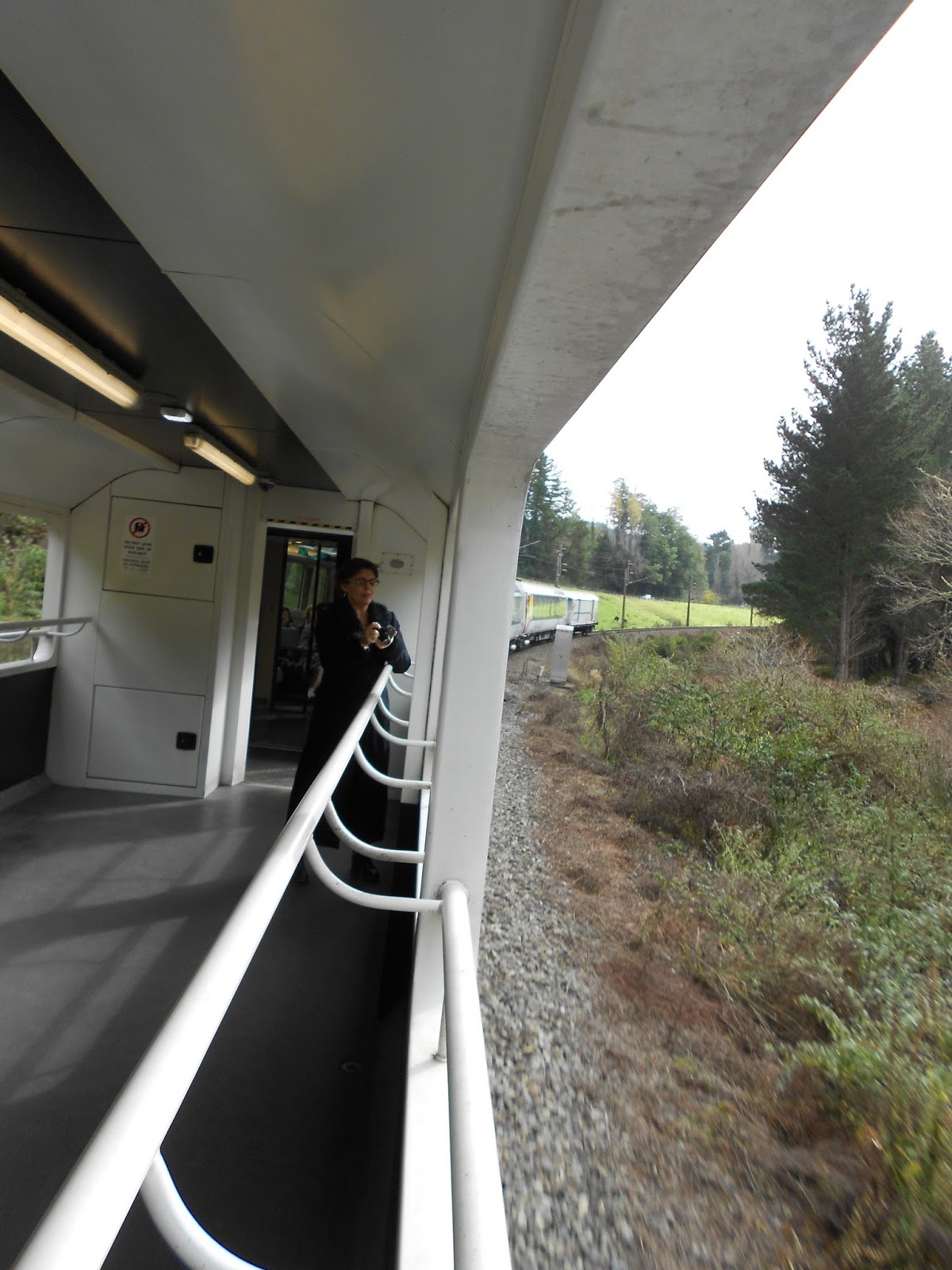
23.K Looking Back along the Train from the Observation Van
23.L A Full Observation Van Whilst Transiting a Raurimu Tunnel
23.M The 'Bush' at the Raurimu Spiral
23.N Woodstock at the National Park Station
23.O Passengers Retrieving Luggage back at the Luggage Van, National Park Station
23.P Lumber Mill in the High Country
23.Q Perhaps a Former Hotel or Rooming House across from Ohakune Station
23.R Somewhere between Taihape and Marton on the North Island Main Trunk Railway


